

- Pack

Reference: ELT0128
Brand: ELTEHS
 5 Review(s)
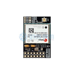
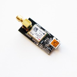
ZED-F9P High Precision GNSS receiver InCase PIN EVAL module USB, I2C, UART, SPI with IPEX (U.FL) antenna connectors. L1/L2 or L1/L5 options. Base or Rover operation. VOLUME SALES PRICING This product comes with 1 years worldwide warranty
Reference: ELT0014
3 Review(s)
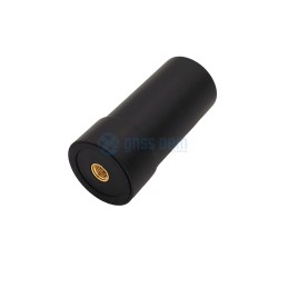
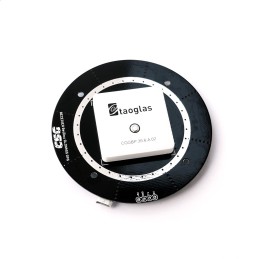
L1/L2/L5 SMA High Performance Helical spiral (IP67 active Antenna) This product comes with 1 years worldwide warranty
Reference: ELT0031
Brand: ELTEHS
 0 Review(s)
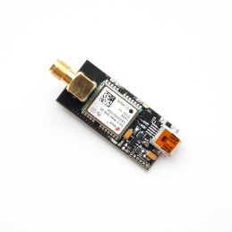
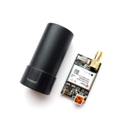
NEO-M8N Product Summary NEO-M8N GPS, GLONASS, Galileo, BeiDou, QZSS and SBAS receiver EVAL USB, I2C, UART module with SMA antenna connector and mini USB. VOLUME SALES PRICING This product comes with 1 years worldwide warranty
Reference: ELT0087
Brand: ELTEHS
5 Review(s)
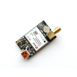
ZED-F9P High Precision GNSS receiver EVAL module USB, I2C, UART, SPI with SMA antenna connectors. L1/L2 or L1/L5 options. Base or Rover operation. VOLUME SALES PRICING This product comes with 1 years worldwide warranty
Reference: ELT0101
Brand: ELTEHS
3 Review(s)
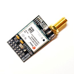
NEO-M9N four GNSS receiver EVAL module USB, I2C, UART with SMA antenna connectors. VOLUME SALES PRICING This product comes with 1 years worldwide warranty
Reference: ELT0092
Brand: ELTEHS
1 Review(s)
ZED-F9P High Precision GNSS receiver InCase PIN EVAL module USB, I2C, UART, SPI with SMA antenna connectors. L1/L2 or L1/L5 options. Base or Rover operation. VOLUME SALES PRICING This product comes with 1 years worldwide warranty
Reference: ELT0100
Brand: ELTEHS
1 Review(s)
NEO-M9N four GNSS receiver with 35mm Antenna and EMI protection VOLUME SALES PRICING This product comes with 1 years worldwide warranty
Reference: ELT0091
Brand: ELTEHS
1 Review(s)
ZED-F9P High Precision GNSS receiver EVAL module USB, I2C, UART, SPI with hign Performance Multi band GNSS Active Quad Helix Antenna ELT0014. L1/L2 or L1/L5 module options This product comes with 1 years worldwide warranty
Pay Pal, MasterCard, Visa, American Express, Discover


")

 multi-band GNSS Development Kit with centimeter accuracy. Base and Rover kits)")
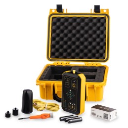
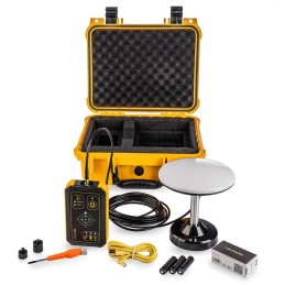
RTK (Real Time Kinematic) multi-band GNSS Development Kit with centimeter accuracy. Base and Rover kits for surveying, mapping and navigation. Rover kit with Helix antenna, Base kit with Survey Antenna with 5m cable and magnetic mount. Both have USB-C connector and 1/4" thread mount in IP67 waterproof case.
This product comes with 1 years worldwide warranty
![]()
 Security policy
Security policy
 Delivery policy
Delivery policy
 Return policy
Return policy
Base kit with Survey Antenna with 5m cable and magnetic mount, Rover kit with Helix antenna. Both have USB-C connector and 1/4" thread mount, IP67 waterproof case. Wireless Bluetooth or Wi-Fi operation, 3xAA internal power supply. Base and Rover operation. Multi-band receiver delivers centimeter-level accuracy in seconds. Designed for surveying, mapping and navigation. Supported different antenna and wireless connectivity options. With the GNSS Development Kit you will have everything you need to start your surveying, mapping and navigation tasks with RTK and centimeter level accuracy. You can use your preferred Android application to connect with GNSS DK by Bluetooth or use u-blox center GPS Evaluation Software to connect directly to ZED-F9P high precision GNSS module over USB-C.
GNSS DK ensures the security of positioning and navigation information by using secure interfaces and advanced jamming and spoofing detection technologies. It comes with built-in support for standard RTCM corrections, supporting centimeter-level navigation from local base stations or from virtual reference stations (VRS) in a Network RTK setup.
Logging
Logging for OpenStreetMap and GPS exchange: GNSS DK support GPX format to store track and waypoints (press Function key to store waypoint) with centimeter precision. GPX files can be directly used in many tracking and mapping applications.
Logging for RINEX: Record RAW data, position and base correction logs in Ublox RAW format. Please download free RTKLIB code and manual for PPP applications. Please use OPUS or other online services to get centimeter-precise results in any place of the Earth.
Logging and other tasks are independent processes and can be used simultaneously. On 2GB internal SD card up to 14+ days of logging at 1Hz can be stored.
Connectivity
GNSS DK provide data in standard NMEA that is used by most GIS applications. Kit utilize mikroBUS™ socket, allowing to use different wireless modules, depending of the application. Several mikroBUS™ Bluetooth modules supported now, WiFi modules support will follow. Direct access to the ZED-F9P GNSS module on USB-C connector allow to use u-blox center GPS Evaluation Software for many applications.
Base station
Lefebure NTRIP client for Rover applications and YCServer for Base applications.
Power
GNSS DK powered from 3xAA rechargeable batteries, we recommend to use Eneloop Pro or similar batteries, as supplied with the Kit. Typical logging time up to 12 hours, Kit can be charged from wall USB charger, computer or power bank.
Antenna
GNSS DK can be used with any external active GNSS L1/L2 antenna with SMA connector. Depending of the application, Helix antenna, Survey antenna or ANN-MB antenna can be used. Survey antenna included into the Base kit.
Environment
GNSS DK designed in small IP67 waterproof case 150x88x34 size and 300g weight and can be used in harsh environment. Case have 1/4" thread mount, allowing to use any typical camera monopod or tripod. 1/4" to 5/8" thread convertor included to use with survey equipment.
Applications
GNSS DK can be used with any your favorite GPS/GNSS application on Android smartphones/tablets in order to get centimeter level accuracy. You only need to setup your device to use mock location for Android. We have tested it with the following popular applications:
also with different land survey and topographic applications:
also with different industrial applications:
Specifications
Kit content
GNSS DK can be used for a Base or Rover operation mode. This kit include both Base and Rover GNSS DK.

Reference: ELT0129
Brand: ELTEHS
0 Review(s)
RTK multi-band GNSS Development Kit with centimeter accuracy.Rover kit for surveying, mapping and navigation with Helix Antenna on SMA connector, USB-C connector and 1/4" thread mount in IP67 waterproof case. This product comes with 1 years worldwide warranty
Reference: ELT0130
Brand: ELTEHS
4 Review(s)
RTK (Real Time Kinematic) multi-band GNSS Development Kit with centimeter accuracy. Base kit for surveying, mapping and navigation with Survey Antenna with 5m cable and magnetic mount, USB-C connector and 1/4" thread mount in IP67 waterproof case. This product comes with 1 years worldwide warranty
 What Are Geodetic Kits?
Logger
Geodesy. Geomonitoring. Topographic Survey
Reviews (1)
5,00/5
What Are Geodetic Kits?
Logger
Geodesy. Geomonitoring. Topographic Survey
Reviews (1)
5,00/5
I recently bought these two sets. The device that was purchased is precisely as linked. I think it is very good quality and a great starting point. The support team were very helpful initially. A free 2 year subscription to YC server is included. Together with SNIP an SW Maps a functional RTK survey can be undertaken more or less out of the box! They were supplied with high quality aerials, well built IP67 enclosures and GRP carry cases. The product consists of identical units with an onboard micro processor that coordinates communication between a Mikrow BLE unit, onboard sd memroy card, and 2no buttons (one for power the other for taking a position reading) and the ZED F9P. The intended operation is that the units load an initiation file that is stored on the sd card on power up. The user can edit this file (by commenting and/or uncommenting out lines in a txt file over a usb connection) so that each unit is set up as either a 'base' or as a 'rover' as required. The initiation (.ini) file consists of proprietary lines of code (they are predefined text strings as opposed to c++, python, or any other language) instructing the micro controller how to configure the baud rate for the ZED F9P and BLE unit. The file also communicates directly with the ZED F9P by means of CFG hex messages that set up the RTCM correction messages etc.
The base unit utilises a BLE connection to send correction data to an NTRIP caster via an app on a mobile phone. It also writes a log both UBX and GPX(Rinex) for PPK later if required.
The Rover receives the correction messages from an NTRIP client {a second mobile phone) via the BLE board on the Rover unit. When a button is pressed a position data entry is made into the UBX and GPX log files on the sd card. I am very happy with this purchase. Thank you for your cooperation
RTK (Real Time Kinematic) multi-band GNSS Development Kit with centimeter accuracy. Base and Rover kits for surveying, mapping and navigation. Rover kit with Helix antenna, Base kit with Survey Antenna with 5m cable and magnetic mount. Both have USB-C connector and 1/4" thread mount in IP67 waterproof case.
This product comes with 1 years worldwide warranty