What is Galileo Galileo High Accuracy Service (HAS)?
The Galileo High Accuracy Service (HAS) provides free of charge high accuracy Precise Point Positioning (PPP) corrections through the Galileo signal (E6-B) and by terrestrial means (Internet) since 24/01/2023. Galileo HAS offers real-time improved user positioning performances down to a decimeter level (in nominal conditions and based on a user PPP processing algorithm).
The main characteristics of the Galileo HAS are:
- HAS corrections: high accuracy corrections are composed by orbits, clocks, and signal biases per each satellite. The HAS full service will include atmospheric corrections too.
- Accessible: high accuracy corrections are accessible through two dissemination channels: E6-B Signal in Space (SiS) and a terrestrial link, which provides an alternate source to the SiS through the Internet.
- Multi-constellation and multi-frequency: high accuracy corrections are computed for Galileo E1/E5a/E5b/E6; E5 AltBOC and GPS L1; and L2C.
- Open format: high accuracy corrections follow a similar format to Compact-State Space Representation (CSSR).
Galileo High Accuracy Service levels
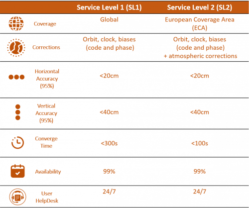
Two service levels are defined for the provision of high accuracy PPP corrections:
- Service Level 1 (SL1): with a global coverage availability, provides high accuracy corrections (orbits, clocks) and biases (code and phase) for Galileo E1/E5b/E5a/E6 and E5AltBOC and GPS L1/L5/L2C signals.
- Service Level 2 (SL2): with a regional coverage availability, over the European Coverage Area (ECA), provides SL1 corrections plus atmospheric (at least ionospheric) corrections and potential additional biases.
The target performances for both SL1 and SL2, at full service capabilities, are presented in the table below:
.
.
Galileo HAS target markets
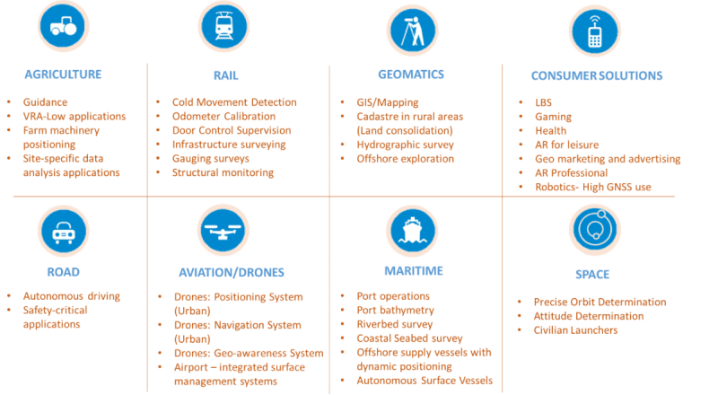
Overview of the most relevant applications that can benefit from Galileo HAS.
.
.
Galileo HAS high-level architecture
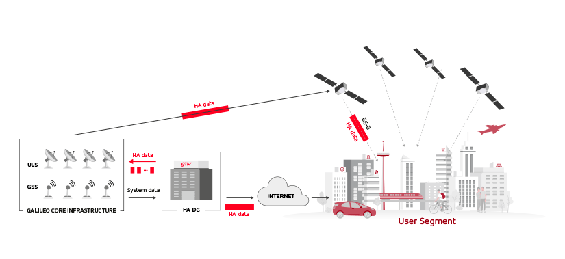
The generation, provision and exploitation of high accuracy corrections involve several Galileo system elements:
- The High Accuracy Data Generator (HADG) module receives data from the Galileo Sensor Stations (GSS) and generates corrections for Galileo and GPS. The High Accuracy (HA) corrections are relayed in real time to the Galileo core infrastructure.
- The Galileo core infrastructure receives the HA data and compiles the information in one single message of 448 bits per second and per connected satellite.
- The Galileo core infrastructure, through the Uplink Stations (ULS), uploads the HA data to the satellites.
- Galileo satellites broadcast HA data through the Galileo E6-B signal component.
- HA data is also provided through the terrestrial link, accessible to the users through the Internet.
- User receivers implement PPP algorithms to apply HA corrections to the Open Service navigation data received via E1-B signal.
.
.
HIGH ACCURACY SERVICE IN GENERAL

HAS Performance Potential Service Level 1 (SL1) Target, 2023:
- 10 cm RMS (H)
- 20 cm RMS (V)
- 300 seconds resolve
- 99% availability
- Global coverage
HAS Performance Potential Service Level 2 (SL2) Target, Future:
- Improve to 100 sec. within Europe
.
.
CONCERNS FOR USE IN THE MACHINE CONTROL MARKET

Most applications:
- 0.5 to 2.0 cm RMS (V)
- Obstructed sky
- 5 sec resolve time
Some applications:
- 10-30 cm Horizontal
- No vertical requirement
- Open sky
.
.
HOW ARE HIGH ACCURACY SERVICE (HAS) CORRECTIONS DIFFERENT THAN OTHER SATELLITE-BASED CORRECTIONS
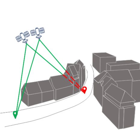
SBAS, typical PPP:
- Use 1-3 geostationary satellites
- Environmental blockages occur
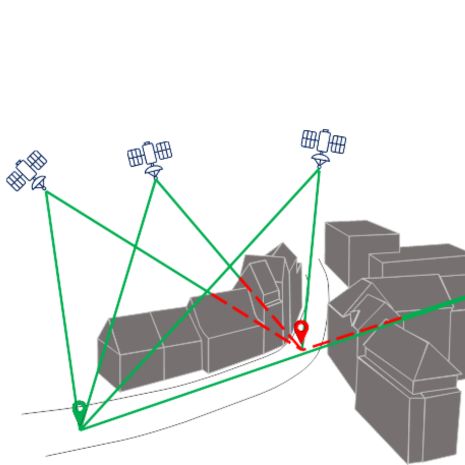
HAS corrections:
- Transmit on MANY satellites
- Improves reception likelihood
.
.
GNSS.STORE support HIGH ACCURACY SERVICE
...............
- GNSS.STORE platforms include E6BC signal capability
- Beta released in February 2023
- Full release in July 2023 with firmware version 6.1.1
.
.
CORRECTION STRUCTURE

- Identical correction fragments
- Received from several satellites simultaneously
- One fragment "wins", others are "redundant"
.
.HIGH ACCURACY SERVICE (HAS) MACHINE CONTROL APPLICATIONS

Constraints and limits:
- Only horizonal positioning
- Open sky conditions
Opportunities:
- Asphalt compaction
- Soil compaction
- Landfill compaction
- Any application where monitoring and logging position within HAS threshold is sufficient
.
.
ASPHALT COMPACTION

“It´s all about data and their position on the maps….”
- Pass count
- Temperature
- Compaction data (vibration)
- Improved up time in urban canyons and difficult environment
- Go Green – Reduced CO2 emissions by less passes
.
.
GALILEO HAS HELPING PEOPLE IN AGRICULTURE

The biggest portion of agriculture applications requires no vertical position accuracy but only 30 cm pass to pass accuracy in horizontal x and y. Good examples for these applications would be spraying with section control included and grass cutting guidance only to name two. The required multi Frequency activation on receivers as an addition even improves performance. Investment for the farmer is similar to Hemisphere´s Atlas Basic lifetime PPP activation, but would drastically increase numbers of tracked satellites and therefore uptime and reliability of signal of the receiver used in the guidance or steering application.
Spraying with section control
- Investment for farmer identical to Atlas Basic PPP Service
- Increased satellite count
- Less taxing on navigation computer
- Reduced risk for blockages
- Improved performance in difficult environment
.jpg)
.
.
HAS ADVANTAGES IN CONSTRUCTION & AGRICULTURE

- Global availability
- Simplicity
- No radio licensing and local frequency requirements
- No radio / cellular / WiFi coverage issues
- Reduced cabling, simple installation
- Fewer points of failure and less blockages
.
.
THE FUTURE…?
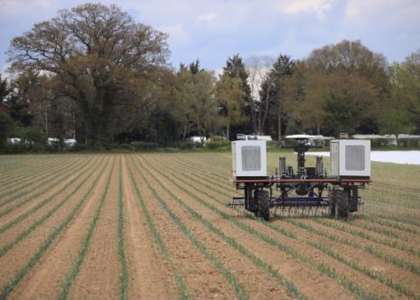
Challenges and opportunities for Robot and Autonomous Driving for NRMM
- New Machinery Directive in 2027
- Setup with PL D or SIL 2
- Cybersecurity
- More autonomous operations will replace traditional working based on reduced availability of skilled workers

