Review for "RTK GNSS DK with cm accuracy for surveying and mapping. Base kit."
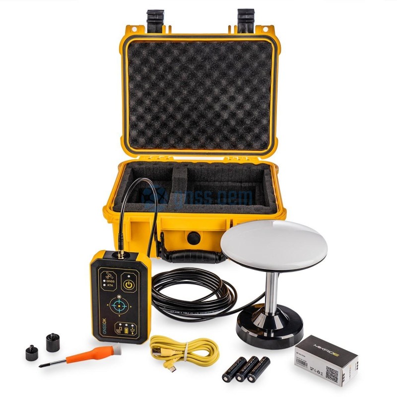
RTK (Real Time Kinematic) multi-band GNSS Development Kit with centimeter accuracy. Base kit for surveying, mapping and navigation with Survey Antenna with 5m cable and magnetic mount, USB-C connector and 1/4" thread mount in IP67 waterproof case. VOLUME SALES PRICING This product comes with 1 years worldwide warranty
Review
 0 of 0 people found the following review helpful
Dear GNSS OEM contact team,
I am interested in purchasing the RTK GNSS Development Kit (ELT0130) with centimeter accuracy for surveying and mapping applications. Before proceeding with the purchase, I have a few questions regarding the product's specifications and usage details. Could you please provide detailed information on the following points?
1. Product Price: What is the current price of the RTK GNSS Development Kit (ELT0130) including all necessary components?
2. Position Accuracy: Can you confirm the exact position accuracy of the kit in RTK mode? What is the expected accuracy in standalone mode?
3. Base Station Range: What is the maximum effective range between the base station and the rover unit? How does the range vary under different environmental conditions?
4. Waterproof Capability: Is the equipment rated for waterproof performance? If so, what is the specific IP rating, and can the kit withstand marine or outdoor environmental conditions?
5. Data Formats: Which data formats does the RTK GNSS Development Kit support (e.g., NMEA, RTCM, UBX)? Are there any specific formats that are particularly recommended for use with Windows systems?
6. Presence of Attitude Sensors: Does the kit include an integrated IMU for attitude sensing? If not, are there options for integrating external IMU sensors?
7. RTK Subscription Fees: Are there any additional costs associated with using RTK corrections? If so, could you provide details on the subscription fees or any third-party services required?
8. Wireless Connectivity: Can the base station and the rover unit be connected wirelessly? What wireless technologies (e.g., Bluetooth, Wi-Fi, UHF) are supported for data transmission?
Thank you for your assistance. I look forward to your response.